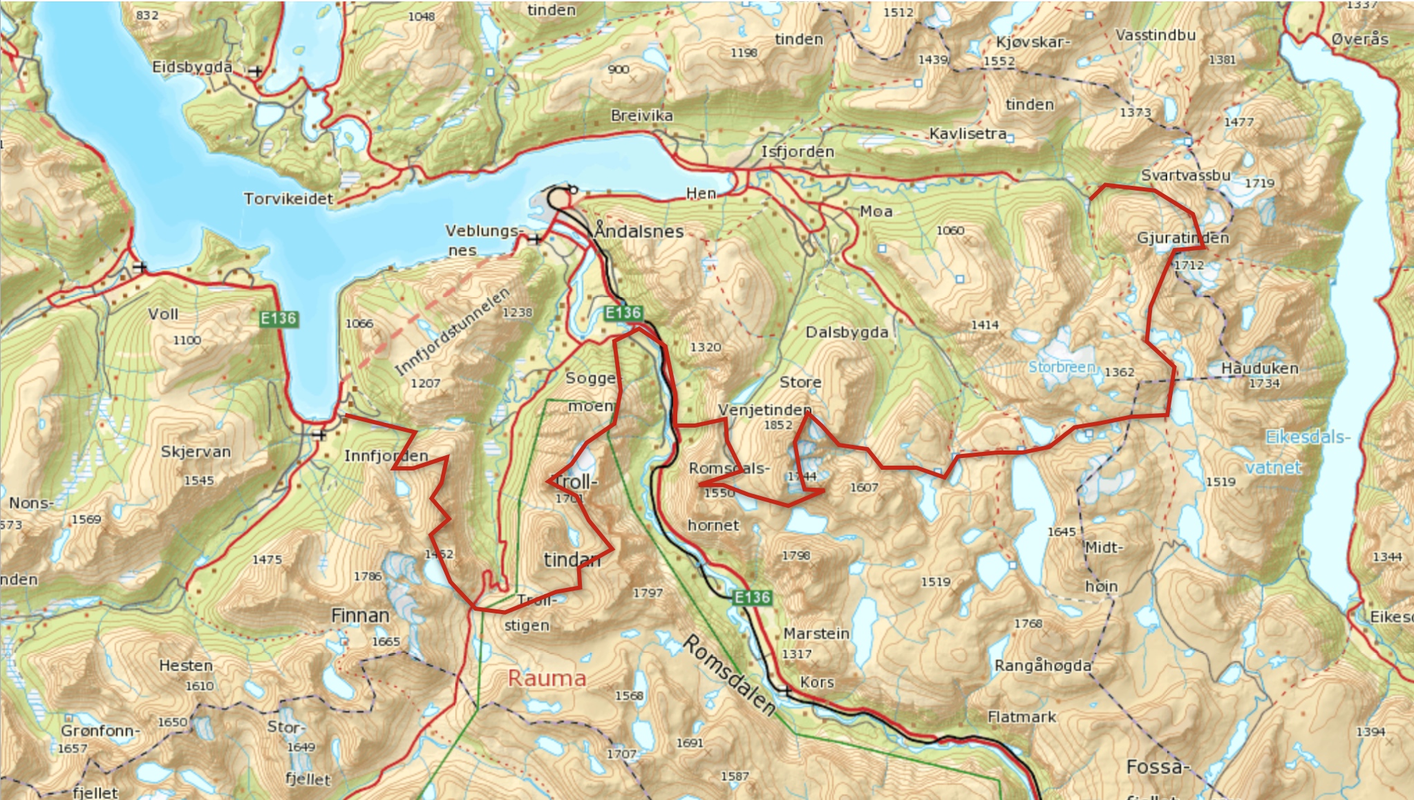
Running crossing linking 7 summits (Gjuratind 1712m, Store Vengetind 1852m, Kvanndalstind 1744m, Romsdalshorn 1552m, Store Trolltind 1788m, Kongen 1614m and Dronninga 1544m) - Total: ± 80km - 9000m. here he track and the move (before it stops)
Food: I carry and eat 3 fruit compote (like a fruit gel) on the 1st half, then I take a wrap when crossing the route in Rauma river and then a cookies pack during the 2nd half of the route. I carry 0.5L soflask that I refill during the run.
I really like linkups and crossings on mountains, just moving over more or less technical terrain from A to B or linking summits, so when we move to Romsdal, Emelie tell me about the linkup 2 friends of us did some years ago. Nils Nielsen and Ola Hovdenak, 2 great alpinists and skiers (both in the Norwigean Skimo National team) climb the 7 summits of Romsal in a single day, using the skis to link the summits and the car from an area to another (summits are on 3 different massifs). Here you can read their journey. Obiously is more than 7 summits in Romsdal, This ones are the part of a local “history-challenge” saying that people who climb this seven summits, the most spectacular or well known in Romsdal area, is the king or queen of the mountains.
I get really inspired of Nils and Ola trip when I start to discover the size of this mountains and I wanted to try myself. I like to have goals or objectives, not big deals but only to keep the motivation, so I start skiing and climbing all this summits to know how they were. It was late winter and I wanted to do a try, the ski racing season was finish and snow conditions where still super good up here, I looked in maps and on terrain trying to find out a route to connect those 3 massifs on skis, finding some conecctions over big valloné areas or steep couloirs. Middle may the guys from Salomon Freeski TV where home to film with me so I decided to try. It was also Philipp Brugger, a talented German skier and climber so we started. Conditions where to difficult; lot of snow, needing to open track over the knees, and then the hot weather turn all this snow to big avalanches. So we stop half way. After that the hot and sunny weather (who tell me in Norway is always raining?) make the snow melt fast and disappear on the lower parts.
I started the running season in Zegama and come back home after to prepare for the season and the coming expeditions and the weather was great. I thought I will leave for next winter this project but running on the mountains I started to think, and running? Why not to try the linkup by foot? So I look to some alternative path to link the mountains and figure-out a possible route.
The weekend was bad weather and we go to Lom for a Vertical Race, the weather for the following week didn’t look terrible, but on Monday it seem to be sunny morning and no wind and I have this day free before some meetings so I decide to try. On Sunday evening, after dinner, Emelie drive me into Grøvdal a bit before 22h and I started running on a wet grass after 2 days raining. The clouds started to disappear soon and it became a beautiful evening. When I reach 1000m I realize that all the rain in lower valleys was fresh snow higher up. It was great; absolute silence, sun rising on the north, opening tracks on fresh snow. I traverse the east glacier and when I came to the ridge I realize how much snow have fall last 2 days. It was a layer of 15cm covering all the rock, not making extreme but much slower and harder to find the route on ridge and covered rocky sections. 2h after I left I scramble up to Gjurantind top just on the runrise moment. That was a kind of a moment. I take south glacier slopes down to the lakes and start to run south and east. With no sun it became pretty cold so I put on my bonatti jacket and long pants. The plan was to take a trail but all the valleys, between 800 and 1200m was fully covered with winter snow, so the way went slower as many times the snow beaked under my feet and I could not run fast. I was worried if it was gonna be possible with all this snow, I expected much less snow on this areas and I was not sure if it was possible to climb up and down Kvandalstind and Romsdalshorn with all the fresh snow. These moments the motivation was so so, but anyway it was midnight and I have not a car so I needed to continue at least until Emelie wake up.
During the short night, just 3h without sun but clear, I run the land between Gjuratind and Venjetind massifs. With the sunset I start to climb up the East slopes of Store Venjetind. On the lower section I take a crack on the face exiting on the east glacier, in winter it was a easy couloir, now it was a waterfall, so I climb in the sides, on slabs rocks, never really steep but some sections where complete “lisas” and were a bit wet so a good test for the grip and adherence. On the glacier I decided to climb up to North ridge instead of the east slopes, because it was to much fresh snow. Around 6h I reach Store Venjetind. It was to much snow to go fast but was a beautiful clear sunny day. I scramble down on the east ridge about hundred meters and take a narrow balcony that traverses the south face until the pass between Store and “Lille” Venjetind. That was beautiful, just a 1m path with vertical wall upside and under. I cross the glacier and ridge until Venjetindan and start Kvandalstind ridge. Is never really technical, (up to IV) but a scenic thin ridge with snow and rocky sections and multiple gendarmes. I was worried about how much snow will be on the last steep wall to the summit but the morning sun was working fast and melting fast some fresh snow and I could climb without problems. It was 8h in the summit and just take a minute to enjoy the views. There the motivation comes back to maximum, on the steep sections the rock started to be dry again. I glide down on the glacier and cross running towards the feet of Romsdalshorn, where I meet some people going to Kvandalstind, It will be the only people I saw today in the mountains, and start climbing the normal route on good pace, this is probably one of the most aesthetic mountains in Romsdal, a black rock pinnacle of 1500m. The route scrambles up on easy terrain with 2 or 3 steeper sections, never hard (IV) but really exposed if fall. A quarter before 10h I was on the summit of Romsdalshorn. My idea was to climb down the north face but the wind started to be really strong and I was worried if it was still snow on the north face, so I climbed down same way up. I run over Litlefjellet, with spectacular views of Trollwall and Romsdalshorn and look down to the valley, 700m under it is the village of Åndalsnes. This is a pretty steep land on both sides of the valley, with multiple walls for rock climbing over 1000m. In the winter I take a steep couloir on Blåneba to go down but for the summer I see only one possibility under the electric cables where a green line of trees was almost continue between the rock walls. The first part of the downhill was a battle with the jungle, hanging on the trees to climb, or mostly glide down on grass and mud and wet rock slabs. I zip-zap on the forest until the last electric pylon, where is a some hundred meters vertical wall and start crossing left until a river, and there is exactly a point between 2 walls, in the top of a big water fall where is possible to cross from the upper forest to the lower forest. I cross over the river trying to make good adherence on wet rocks. I just look to my phone to see if I was on the good place (Is really useful to have a maps app when in mountains, here in Norway is Norgeskart) and when I was putting the phone back to my pocket it just slip from my hand and fall on the waterfall for some hundred meters. I climb down in the forest and look for a while on the feet of the waterfall if I saw the phone (it is a resistant phone, maybe it survived from the fall) but I didn’t find-it. I continue on some animal tracks that make-it easy until I reach the route E 65. For once, it feels good to run on asphalt, being able to run fast after some runwalking breaking snow and gliderunning on trees. I saw Emelie on a bike and run with her on the road until X Camping. She brings to me an abocado and tomato wrap and a pocket of cookies. I ate the wrap and put the cookies on the backpack. The day was warm and no one cloud on the sky and I was confident, the biggest difficulties were on the back and now it was mostly a matter of endurance. A bit before 13h I start running up the trail to Norafjellet. When I reach the North glacier of Store Tolltind I feel a bit low, it was one of those down moments during a long distance run, when you feel not any specific problem (no legs hurt, no cardiovascular tired, no need of energy) but is on the cycle of up and downs on the long distance runs. I ate some cookies and cross breaking on the snow over the right of the circus. The times I have been here before I climbed a straight couloir to the right of Store Trolltind, but that was on winter when the icefall was formed and anyway a short but 85 degrees ice section will be hard with one iceaxe and no crampons. So I saw on a topo that it was possible and easy to climb up on the right part of the circus and then take a easy ridge to the summit. I climb up to the bergschrund, I was happy I bring-it the ice axe, during all the crossing the snow was soft on top but, on most parts, under it was a hard layer, and it is never steep, maximum 45-50 degrees but is much easier and safer with one axe. I left the snow and start climbing the wall. on the topo it says Norwegian II class, when it says II class is normally “you will not be hanging on your arms but will be exposed”, It didn’t look hard but the first few meters where pretty steep and with water falling all the wall. I find a way up to the ridge that it was fully covered with snow and ice. It was cold, with some strong wind and when I look to the sky it was fully covered by black clouds. I put my jacket and pants and take the ridge up. Being north, the snow didn’t melt and it was a lot of ice in the ridge, a really loose rock ridge I would say. It was really laborious breaking the ice with the ice-axe to free some hold for my feet or hand and testing every rock. Finally I came to a larger ridge where I could run to the north pass. On this moment the sunny moments looked really far away and it started to rain and snow depending the moments, the wind was intense. I scramble up to Store Trolltind on a big storm, I was cold, my hands on the wet gloves didn’t have any feeling anymore, and my feet was floating on the shoes. In the summit it was a crazy wind with rain, I did not stop a second, just touch the rock pile and start scramble down. I saw some tracks on the fresh snow on the way back, so I follow them on the snow. The rain was intense and the wind didn’t decrease, the rock was more than wet so I could not take a fast speed on the downhill. I was worried about Emelie, she was waiting for me in Trollstigen and I was about 1h30 later than I expected. The motivation was the lowest now. It was so cold, so wet and the wind really strong. I thought I could not continue, either if the 2 summits left were not really technical it was still long, around 1500 more meters, and Droninga have some steep scrambling, It was to much wet and to much stormy to continue. So close to the end to finish, anyway it was a great day, a great training to move so many hours on this terrain with this conditions. When I come to trollstigen it the rain did stop. It look obvious for Emelie I was going to continue so I did. I power hike up to the feet of Kongen on a ok weather before it start to raing again strongly with intense wind. The ascent of Kongen is a walking trail with easy scrambling to the top. The shape was there again so it took only one hour to reach the summit. The crossing to Dronninga was cold and wet, is never hard but exposed terrain in wet rocks towards the south ridge, and one hour after I was finally in the last of those 7 summits. Some easy scrambling, a long running ridge and a trail on the valley drive me into Innfjorden, a bit before 8h30, 23h28 minutes after start running, completely wet and a bit hungry but happy of this great day outside.
Thanks Nils and Ola for the inspiration and Emelie for the support during the day, Now it will just gonna be great to do-it in skis next winter.